The store will not work correctly when cookies are disabled.
We use cookies to make your experience better.To comply with the new e-Privacy directive, we need to ask for your consent to set the cookies. Learn more about our cookies policy.
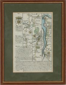
A charming double sided 18th century road strip map showing the route from London to Harwich -- via Stratford, Ilford, Romford, Brentwood, Chelmsford, Witham, Kelvedon, Colchester, Lawford and Manningtree -- which appeared in John Owen & Emanuel Bowen's Britannia Depicta or Ogilby Improv'd (London: T. Bowles, 1720-c.1764). This is an original copperplate engraving with later hand colour.
The map has been presented in a double sided glazed wood frame with green card mount and brass hanger.
On laid.
Condition
In fine condition.
Size
26.8 x 20.7cm (10.6" x 8.1")Framed Size: 26.6 x 20.5cm (10.5" x 8.1")